Local News
From rock collector to museum creator, 11 year old Reese McCallum follows her passion
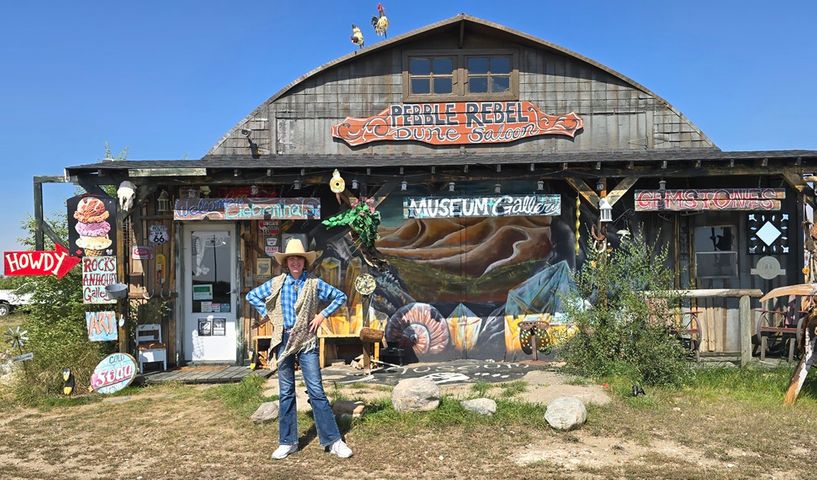
What began as a childhood hobby has grown into something much bigger for Reese McCallum. At just 11 years old, Reese has already turned her love of rocks and minerals into a museum, a creative business, and a workshop where she cuts and polishes stones to reveal the colours and patterns hidden inside. 'Pebble Rebel Dune Saloon' is located near Liebenthal, in West Central Saskatchewan. Her passion goes far beyond collecting pretty rocks. Reese wants to understand where they come from, how they formed, and what makes each one special. She also enjoys sharing that knowledge with others, guiding visitors through her collection and explaining the stories behind the pieces. Step inside her museum, and it quickly becomes clear that this is not an ordinary collection. Cabinets filled with colourful gemstones sit alongside ancient fossils, glowing rocks, unusual antiques, and tools used to shape stones. Every corner offers something new to discover, and Reese is ready to explain it all. For her, every rock has a story. Related Stories: Southwest History: If rocks could talk pt. II, over 1,000-year-old carvings A hobby that kept growing Reese's interest in rocks and minerals began when she was about six or seven years old. At first, she collected rocks simply because she enjoyed finding them. But as her collection grew, so did the possibilities. A family friend invited Reese to take part in a marketplace through the Leader Chamber of Commerce, giving her an opportunity to sell some of the rocks she had collected. That experience sparked a new idea. Reese began learning how to cut and polish stones, turning some of her finds into pieces that could be used in jewellery or displayed as gemstones. Before long, travelling back and forth to the marketplace with her growing collection became a lot of work. The family decided it would make more sense to create a permanent place where people could see her collection and learn about her work. That is how the museum began. "My museum's been operating for four years," Reese said. The museum grew in stages, with more space added as the collection expanded. What started as a way to share and sell rocks gradually became a place where visitors could explore everything from fossils and minerals to handmade jewellery and the tools used to create it. Reese was asked to choose her favourite part, and she has a hard time narrowing it down. "Probably the 'Gemmy Jelly Gemstone' cabinet and the fossil section," she said. "This is a term that top collectors and lapidarian's call the very high grade gemstone material because it resembles Jelly. The more clear and candy like and colourful the gemstone is, it makes it highly prized." It is easy to understand why. Each section represents a different interest, a new skill, or something she has discovered along the way. More than just pretty rocks One of the most impressive things about Reese is how much she knows about her collection. She can explain the differences between types of rocks, point out details in fossils, and describe how certain stones get their colours and patterns. Among the museum's highlights is 'Big Red', a fossil that Reese says is about 65 million years old. The fossil was donated to her museum in 2024 by Jason Berkholtz the owner of Alberta Fossil Family that is based out of Alberta. The fossil is from an ammonite, an ancient sea creature that lived millions of years ago. Its shell has distinctive patterns that Reese is happy to show visitors. The collection also includes rocks that glow under special lights. Some appear ordinary in daylight but reveal bright colours when the lights are turned off and a black light is used. There are also displays explaining how gemstones can be natural, imitation, or made by people to look like the real thing. One particularly unusual collection features materials that have been turned into decorative stones, including layers of old automotive paint. Known as Fordite, the colourful material comes from layers of paint that built up in automotive factories. For Reese, these displays are about more than showing people something unusual. She wants visitors to understand what they are looking at and why it is interesting. She also enjoys finding rocks close to home. The surrounding area has provided her with pieces of petrified wood, quartz, jasper, garnets, and other minerals. Some of her collection has been found herself, while other pieces have come from people who have donated specimens they collected over the years. Those donations mean a lot to Reese because they allow her to show visitors things they might never have seen before. Everyone finds something different, and one person's discovery might become another person's favourite display. That is part of what makes the museum special. It brings together discoveries from different people and places, giving each specimen a chance to be appreciated. Turning rough stones into something beautiful Located in the family home is Reese's workshop, where she does much of her cutting, shaping, and polishing. This is where the work is done that turns a rough rock into a finished gemstone. The process takes patience. Reese must choose the right stone, decide how to cut it, and work carefully to bring out its natural colours and patterns without damaging it. She uses specialized machines to shape stones into smooth, polished pieces called cabochons. These are often used in jewellery and have rounded surfaces rather than the many flat faces seen on some gemstones. Reese has also been learning how to make gemstones with carefully cut surfaces that reflect light. Her equipment has developed as her skills have grown. Her father even built her from scratch a gem carving machine, It is called a Faceting machine, which she has kept on display in the museum. She later upgraded to another machine as she continued learning. 'The moter from it is just a basic second hand motor out of an old washing machine that was from out of one of our old grain sheds." She said. "Dad took it apart and refurbished it and the reason he did that is because a washing machine motor outputs the same RPMs as a regular flat lap." She has also connected with experienced stone workers who have helped her improve her skills. One of those mentors is Frank Burns, also known as Facet-Nating Frank. Many of the high-grade Faceted gemstones that are in the museum are carved by Frank. Frank teaches Reese how to cut gemstones. "He is amazing to learn from because he is so much fun, but he is very picky about the math of gem carving artwork, so he is a very good teacher." She said. "I have learned from his videos on facebook and private videos if I need help." Reese has also learned about fossils from Burkholdt, who has shared his knowledge and helped her explore new opportunities. Those connections have allowed Reese to learn from people who have spent years working with rocks and minerals. She has visited a laboratory where geological samples are studied, travelled to a gold-mining site in British Columbia, and tried panning for gold with experienced miners. The experiences have given her a chance to see how rocks and minerals are found and handled outside her own workshop. Reese said visiting the gold mine and learning from the people there was one of the highlights of her journey. She loves the mountains, and the opportunity to explore for gold while learning from others combined two of her interests. Each experience has added something new to her knowledge and given her another reason to keep exploring. A business built around creativity The museum is only one part of Reese's growing business. She also makes jewellery and other items using stones and metals, combining her interest in collecting with her creative skills. Some of the metal she uses comes from recycled plates and platters, which she turns into new creations rather than letting the material go to waste. Her gift shop includes pieces she has made herself, alongside other items for visitors to explore. She has also developed interactive products that let people search through sand to discover hidden gemstones. It is another way to bring the excitement of finding something special into the museum experience. Running a business also means learning about things that happen away from the workbench. Products need to be prepared and priced, the collection needs to be organized, and visitors need a place where they can explore safely. Reese's family has played an important role in making it all possible. Her mother has painted artwork for the museum and helps with the business, while her father has supported her work and even built equipment for her. Together, they have helped turn Reese's interest into something that continues to grow. They have also learned that supporting a young entrepreneur means helping her navigate business decisions and understand the responsibilities that come with selling her work. For Reese, though, the creative side remains a major part of the appeal. Every stone offers a different challenge, and she can never be entirely sure what patterns or colours she will find once she starts cutting. Sometimes, the finished piece reveals something she did not expect. Always something new to discover The museum has continued to change as Reese's interests have expanded. Alongside the rocks, fossils, and gemstones, visitors can find antiques, unusual objects, and other collections. The family has also developed an outdoor astronomy viewing area with telescopes, creating another opportunity to explore the world beyond the museum. Still, Reese continues to return to the things that started it all: finding rocks, learning about them, and discovering what can be created from them. She has already developed skills that take time and patience to learn, but she is not finished exploring. There are more stones to cut, more techniques to practise, and more people to learn from. Some projects will take additional time and experience, while others will grow out of the next unexpected discovery. For Reese McCallum, the journey is not about reaching a point where there is nothing left to learn. It is about continuing to ask questions, trying new things, and sharing what she discovers with others. A rock that someone else might walk past can become the beginning of a new project. A donated fossil can spark a conversation about life millions of years ago. A rough stone can turn into a gemstone with colours and patterns that were hidden until Reese began working on it. Her story is a reminder that a small interest can grow into something much bigger when it is given time, support, and room to develop. And for Reese, there is always another rock waiting to be picked up, another story waiting to be told, and another discovery just around the corner.























 Mon, Oct 26, 9:00 AM

 Seasonal, Labour
 Featured